Which Areas in Bangkok Have the Lowest Flood Risk? Ranking 8 Zones Based on Geography
Introduction: No Location is "100% Flood-Proof," But Some Are "Less Risky"
Images of the Great Flood of 2011 and heavy rainfall turning streets into canals in some years make many people ask before buying a house or condo, "Which neighborhood doesn't flood?"
The fact is, Bangkok is on a very low-lying floodplain. The average ground level is only about 0-2 meters above mean sea level, so no area is 100% safe. However, the risk level varies significantly due to the following geographical factors:
1. Elevation: The lower the area, the more water stagnates and the harder it is to drain.
2. Position Relative to Flood Defenses: Areas "inside the flood levee" and "outside the levee" have very different risk profiles.
3. Floodwater Path: Northern runoff flows south through the Chao Phraya River and the eastern/western floodplains of the city.
4. Drainage Capacity: Includes canals, drainage pipes, giant tunnels, pumping stations, and monkey cheeks (water retention areas).
5. Land Subsidence: Areas where groundwater was historically extracted have sunk lower than before.
6. Influence of Tidal Surge: The closer to the Gulf of Thailand, the higher the long-term risk.
Before Reading the Rankings: 3 Types of Bangkok Floods
Understanding the types of flooding helps in interpreting the rankings correctly:
Fluvial Flood: Water from the Chao Phraya River and upstream areas, such as in 2011.
Pluvial/Flash Flood: Heavy rain exceeding drainage capacity. The BMA is designed to handle about 60 millimeters per hour; anything more can cause flooding even in the city center.
Tidal/Coastal Flood: Caused by high tides and storm surges, affecting areas near the Gulf of Thailand and the river mouth more.
The rankings below consider all 3 types, prioritizing fluvial floods and stagnant flash floods that take a long time to drain.
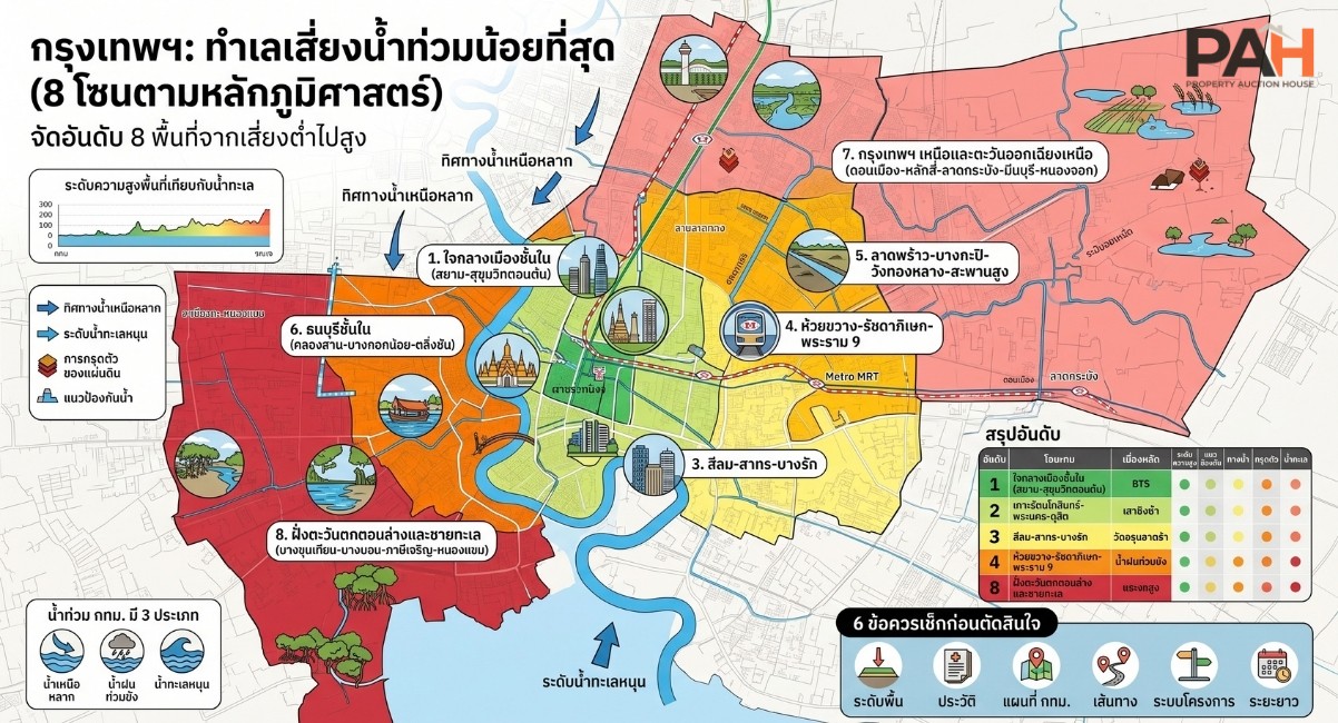
Ranking 8 Bangkok Zones from Lowest to Highest Risk
Note: This is a general assessment based on geography and flood history. The actual risk of each project may vary at the alley level.
Rank 1: Inner City, East of the River (Siam - Ratchadamri - Phloen Chit - Lower Sukhumvit)
Total Risk: Low
Within the main defense line: This area is inside the levee system that the BMA prioritizes as the economic hub. In 2011, this area was hardly affected by northern runoff directly.
Dense drainage system: Equipped with the Saen Saep Canal, large drainage pipes, and supporting pumping stations.
Natural levee ridges: Many main roads were developed on slightly higher ground than surrounding areas.
Points to watch: Deep alleys and low-lying spots may have temporary flooding during heavy rain, but it usually drains within a few hours.
Rank 2: Rattanakosin Island - Phra Nakhon - Dusit
Total Risk: Low
Located on natural levees: Ancient communities chose to settle on high ground near the river, formed by natural sediment accumulation.
Chao Phraya flood defenses: Defenses along the river help prevent overflow, designed to be about 2.5-3 meters above mean sea level.
Surrounded by canals: Helps receive and transfer water.
Points to watch: Older buildings may have outdated drainage, and some riverside spots rely on sluice gates.
Rank 3: Silom - Sathon - Bang Rak
Total Risk: Low to Medium
Protected by riverside defenses: It is a business district with high investment in drainage.
Weak point is land subsidence: Parts of the area are on soft soil and have experienced subsidence, lowering the ground level.
Points to watch: Rama IV Road and the Khlong Toei area have low spots that flood during heavy rain.
Rank 4: Huai Khwang - Din Daeng - Ratchadaphisek - Rama 9
Total Risk: Medium
Well-protected compared to Northern and Western Bangkok.
Pluvial flooding is the main issue: Ratchadaphisek Road and surrounding alleys have flooded during heavy rain that exceeds pipe capacity.
Pros: Equipped with tunnels and pumping stations; water usually recedes faster than in outer areas.
Rank 5: Lat Phrao - Bang Kapi - Wang Thonglang - Saphan Sung
Total Risk: Medium
Low-lying plain on the east side: Water from upper areas and local rain collect here.
Lat Phrao and Saen Saep Canals: Act as main drainage routes, but if canal levels are high during continuous rain, drainage slows down.
Points to watch: Deep alleys connecting small pipes to secondary canals.
Rank 6: Inner Thon Buri (Khlong San - Bangkok Yai - Bangkok Noi - Taling Chan)
Total Risk: Medium to High
West of the Chao Phraya with many canals: Canals serve as both drainage routes and entry points for northern runoff.
Taling Chan and western fringes are water reception areas: In 2011, many outer Thon Buri areas were flooded for a long time.
Pros: Riverside areas near the city center are better protected than outer zones.
Rank 7: Northern and Northeastern Bangkok (Don Mueang - Lak Si - Sai Mai - Bang Khen - Lat Krabang - Min Buri - Nong Chok)
Total Risk: High
Gateway for northern runoff: Areas in the north receive water flowing from the upper central region before it reaches the inner city.
Eastern side is a low-lying plain: Nong Chok, Min Buri, and Lat Krabang are traditional floodplains used to retain and delay water, leading to long-standing floods during heavy rain or runoff.
In 2011: Many neighborhoods in this group were flooded deeply for several weeks.
Pros: Currently, there is increased investment in monkey cheeks and drainage canals.
Rank 8: Lower West Side and Coastline (Bang Khun Thian - Bang Bon - Phasi Charoen - Nong Khaem)
Total Risk: Highest in the long term
Close to the Gulf of Thailand: High risk of tidal surges and coastal erosion in Bang Khun Thian.
Low ground level and significant historical subsidence: Combined with rising sea levels, draining water is difficult.
Many areas are outside main defense lines: Deep soft soil layers.
Note: Long-term risks are increasing due to climate change.
Ranking Summary Table
Rank | Zone | Main Risk | Key Factors |
|---|---|---|---|
1 | Siam-Ratchadamri-Lower Sukhumvit | Low | Inside defense, good drainage |
2 | Rattanakosin-Dusit | Low | Natural ridge, protected |
3 | Silom-Sathon-Bang Rak | Low-Medium | Protected, but subsiding |
4 | Huai Khwang-Ratchada-Rama 9 | Medium | Mainly pluvial flooding |
5 | Lat Phrao-Bang Kapi | Medium | Low-lying, canal drainage |
6 | Inner Thon Buri-Taling Chan | Medium-High | Many canals, near west flood path |
7 | North/Northeast | High | Receives northern water, floodplain |
8 | Lower West-Coastline | High long-term | Tidal surge, subsidence |
Geographical Reasons Explaining These Factors
1. River Delta: Bangkok was formed by Chao Phraya sediment accumulating over thousands of years; the area is flat and low.
2. Natural Levees: Coarser sediment settles near the river banks, making them higher than the surrounding plains, which is why old communities are riverside.
3. Direction of Flow: Northern water flows south. The inner city is protected by flood barriers and drainage, pushing the risk to outer areas.
4. Land Subsidence: Historical groundwater extraction caused soft soil to compress. While the rate has slowed, the lowered ground level does not bounce back.
5. Rising Sea Levels: Slows down drainage into the Gulf of Thailand, especially during high tide.
6 Things to Check Before Buying or Renting
Check the ground level of the project: Compare it to the road in front. Is the ground floor raised?
Ask about actual flood history: From current residents, the juristic person, and neighbors.
Check the BMA flood risk maps: And data from the Department of Disaster Prevention and Mitigation.
Check entry/exit routes: Even if the project doesn't flood, if the main road does, daily life is difficult.
Check the project's protection system: Such as underground parking, electrical rooms, water pumps, and backup power plans.
Consider both heavy rain and long-term trends: As stagnant flooding is more common than northern runoff.
Frequently Asked Questions (FAQ)
Q: Which neighborhood in Bangkok has never flooded?
No area can guarantee it has never flooded. However, the city center has a lower chance of temporary flooding and drains faster.
Q: Is a city-center condo safer than a house?
Regarding floods, a high-rise condo has an advantage in terms of property damage, but you still need to look at access and the building's electrical systems.
Q: Is a house near the Chao Phraya River risky?
It depends on whether it is inside or outside the defense line and its height relative to that defense. Riverside areas outside the levee are much riskier.
Q: What information should I use to make a decision?
Elevation data, BMA flood risk maps, project flood history, and information from actual residents.
Summary
Ranked from "lowest risk" to "highest risk," the inner city and Rattanakosin Island have the advantage due to flood defenses, natural levees, and dense drainage. Outer northern, eastern, and lower western areas are at higher risk due to low elevation, their role as water reception areas, and long-term tidal surge risks. However, this is a general geographical overview. Before deciding, always check the latest data from relevant authorities (BMA, DDPM) and visit the site personally as situations evolve with new infrastructure and climate changes.
Note: Data regarding elevation, defense heights, and subsidence rates in this article are general estimates. Always verify with official agencies before publication.